
Join Our Mailing List

Sign up to receive updates on our latest news and events. Your email will never be shared or sold and you can opt out at any time.

No thanks
CSE:RUC OTC:RUCCF FSE:V0O0

Cross Lake Uranium Project

2,048
Hectares
2.4 km
Structural Lineament
3
Uranium Showings
100%
Interest Available Under Option
Project Overview

A Drilled Uranium Zone
in Saskatchewan

The Cross Lake Uranium Project covers 2,048 hectares southwest of the Key Lake Mine in Saskatchewan's Athabasca Basin. Announced on September 22, 2026, the agreement gives Radiant the option to obtain a 100% interest from Bromell Mining LLP, subject to a 1% net smelter return royalty and fulfillment of the agreement terms.

Pegmatite-hosted uranium mineralization is traced along a 2.4 km northeast-trending structural lineament through the Narrows, Portage and Cross zones. Historical drilling at Narrows provides a foundation for further exploration, with twinning and infill drilling required to advance the historical estimate to a current mineral resource.

Athabasca Basin, Saskatchewan

A 2,048-hectare property southwest of the Key Lake Mine in an established Canadian uranium district.

Three Identified Showings

The Narrows, Portage and Cross uranium showings occur along a 2.4 km structural lineament.

Historical Exploration Foundation

The 1979 Narrows work and a small 2008 drill program provide evidence for further evaluation of the property.

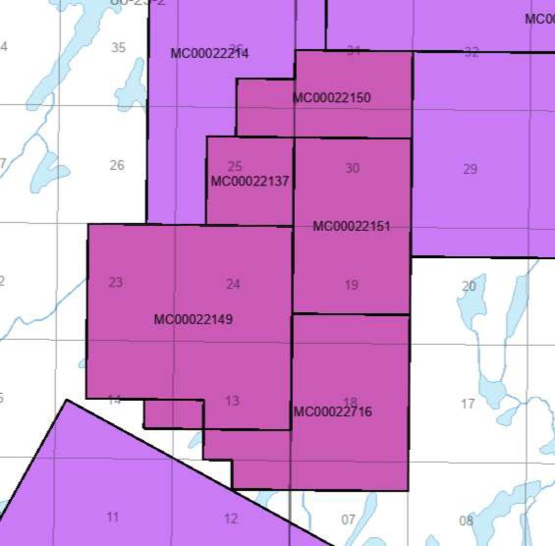
Cross Lake mineral claims map from the corporate presentation
Property ClaimsCross Lake Mineral Claims · Click to enlargeSource: Radiant Uranium corporate presentation, September 2026.
Geology & Mineralized Zones

Pegmatite-Hosted Uranium,
Three Mineralized Zones

Cross Lake uranium mineralization is associated with pegmatitic garnetiferous gneiss along a 2.4 km northeast-trending structural lineament. Mineralized zones have been identified at the Narrows, Portage and Cross showings.

At the Narrows Zone, historic work outlined mineralization over a true width of approximately 11–15.8 metres, with drilling testing the zone to about 75 metres depth. These results describe historical exploration; they do not establish a current mineral resource.

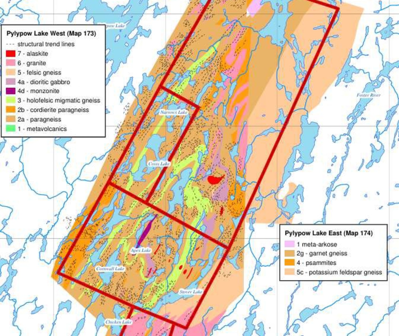
Cross Lake bedrock geology showing Pylypow Lake maps 173 and 174
Bedrock GeologyCross Lake Geological Setting · Click to enlargeSaskatchewan Ministry of Energy and Resources; Pylypow Lake West (Map 173) and East (Map 174), as reproduced in the corporate presentation.
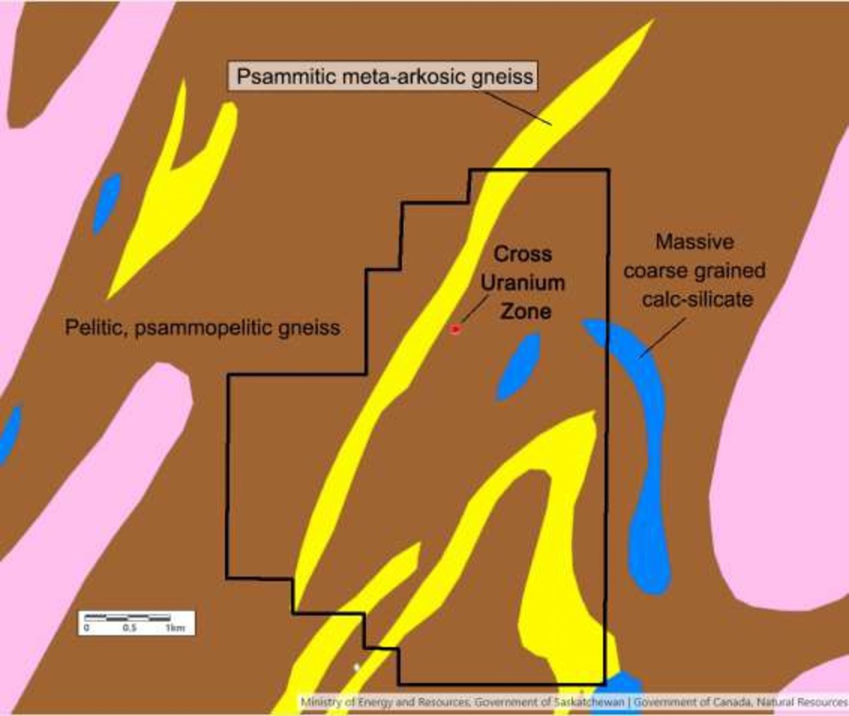
Cross Uranium Zone on the psammitic meta-arkosic gneiss trend
Property GeologyCross Uranium Zone · Click to enlargeMinistry of Energy and Resources, Government of Saskatchewan / Natural Resources Canada, as reproduced in the corporate presentation.
Historical Exploration

Historic Estimate &
2008 Drilling

The Narrows Zone's 1979 historical estimate and Uracan's later drilling provide the exploration context. Further technical work is required to establish a current mineral resource.

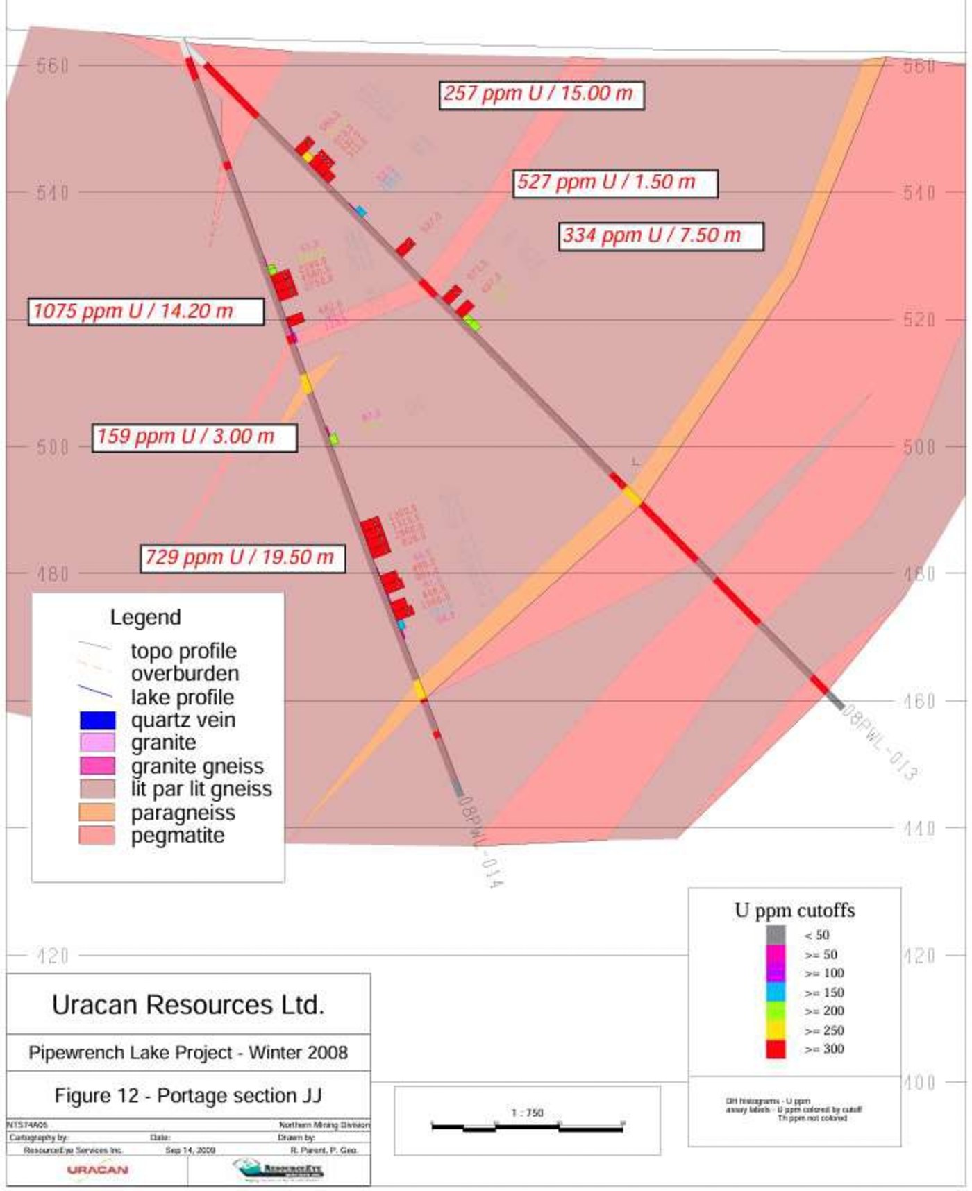
Historical Portage Zone cross section JJ from Uracan Resources Winter 2008 program
Historical Cross SectionPortage Zone — Section JJ · Click to enlargeUracan Resources Ltd., Pipewrench Lake Project — Winter 2008, Figure 12. Historical drill intervals; true widths are not established here. Separate from the 1979 Narrows estimate.
1979
Historical Estimate

Winter Drilling at Narrows

Bralorne Resources' estimate used blocks based on true thickness and half the distance between mineralized intersections on 50 metre plans, with the deepest intersection in hole 41-3 at 71 metres vertical. The original author noted that drilling was not detailed enough to prove the structure or estimate proven reserves.

2008
Follow-up Drilling

Uranium Confirmed in the Area

Uracan Resources' 2008 program confirmed uranium in the area of the historical estimate. The Portage section JJ figure reproduced in the corporate presentation shows 1,075 ppm U over 14.20 metres and 729 ppm U over 19.50 metres. These are historical drill intervals; true widths are not established here.

Sources: Bralorne Resources Limited, 1979 Winter Drilling of the Narrows Zone ML 5255 (Formerly CBS 1074), Foster River Area, Saskatchewan, Rene Bissonnette, May 12, 1979; Uracan Resources Ltd., Pipewrench Lake Project — Winter 2008, Figure 12, as reproduced in Radiant's corporate presentation. Historical results have not been verified by the Company and are not treated as current.

Looking Forward

Path to a
Current Resource

Twinning of historic holes and infill drilling would be required to advance the historical estimate to a current mineral resource.

Twin Historic Holes

Twinning a number of historical drill holes would be required as part of the work to evaluate the historical estimate.

Infill Drilling

Infill drilling would also be required to move the historical estimate to a current mineral resource.

Technical Evaluation

The historical estimate remains unclassified as current mineral resources or reserves. Further work is required before it could be treated as current.

The September 22 release identifies this work as a requirement; it does not announce a drilling schedule. Read the September 22, 2026 release

View the Corporate Presentation

Technical disclosure: This page draws on Radiant Uranium Corp.'s September 2026 corporate presentation and September 22, 2026 release. The technical information in that release was reviewed and approved by Tim Henneberry, P.Geo., a Qualified Person as defined under National Instrument 43-101 and a consultant to the Company.

Join Our Mailing List

Sign up to receive the latest news releases, project updates, and investor materials from Radiant Uranium Corp. Unsubscribe at any time.